
The Christmas Flood of 1991
The dramatic "Christmas Flood" of 1991 highlighted how LCRA manages the river and lake system during major flood events.
Central Texas December 18 to 23, 1991
Central Texas
December 18 to 23, 1991Storm 15.5 inches
Max. Precipitation: 12
Deaths: 43 Million (approx.)
Damage "The Christmas Flood of 1991"
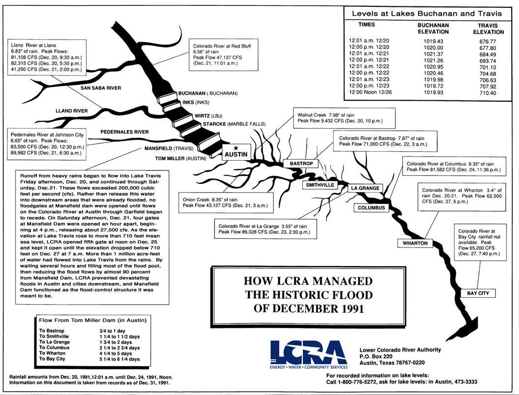
The dramatic "Christmas Flood" of 1991 highlighted how LCRA manages the river and lake system during major flood events. In late December of that year, a large storm moved in from the Gulf of Mexico with heavy rains causing flooding downstream of Austin. By the following day, the rainfall continued over a greatly expanded area, bringing tremendous flows both above and within the lake system while flooding continued downstream. As the situation worsened and storms moved into the Hill Country, LCRA began holding water back in Lake Travis, the only flood-control reservoir on the lower Colorado River, to reduce flood impacts downstream. During floods, LCRA directs river operations from its headquarters, where careful monitoring dictates a quick and judicious response in the operation of the dams.
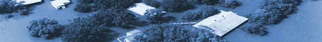
In this particular case, it was clear that the flood storage capacity of Lake Travis would have to be used to catch and hold the tremendous volume of water in its flood storage pool to help prevent more severe flooding downstream. And Lake Travis, via Mansfield Dam, did its job exactly as it had been designed. Lake Travis rose 33 feet over four days. Many lakeside residents were caught off guard by the rapid rise, and hundreds of homeowners who had built within the lake's dedicated floodwater storage pool were harshly reminded of the implications. While flooding occurred at various points along the entire river, Lake Travis was hit particularly hard.
------------------------------------------------------------------------------------------->


Storm Description (from USGS)
December 18 to 23, 1991
Record-breaking peak discharges were recorded at several streamflow-gaging stations in a large area of central Texas Dec. 18-23. Daily rainfall totals exceeded 4 in. at numerous locations. Maximum recorded 24-hour rainfall was 8.6 in., and maximum recorded 12-hour rainfall was 7.3 in., both at Evant in Coryell County. Medina had 15.59 in. during 5 days. read more...
Deaths and Damage: Ten deaths were attributed to the flooding. The Federal Emergency Management Agency dispensed about $43 million.
Max. Precipitation: 8.60 in.
Severity: Catastrophic
Storm Center(s): Coryell Co., Evant
References: Asquith and Slade, 1995; Hejl and others, 1996
Further detail from John Patton of the National Weather Service:
A stalled long wave Dec 18th over Arizona extended into the Sonoran Desert of northern Mexico. The upper low was reflected at the surface along the Arizona/Mexico border. A series of cold air masses pushed from the Pacific Northwest across the Central Plains into the southeastern U.S.
A cold-air-induced surface high was centered over Georgia. A stationary front in central Texas marked the southern periphery of the cold air masses moving across the Central Plains. At low levels, clockwise flow around the southeastern high brought a long fetch of very warm moist air across the Gulf, across the Texas Coastal Bend, and into central Texas as a low-level jet. The weather station at Corpus Christi measured 850 mph winds of 60 to 70 knots from about 160 to 170 degrees for the duration of the storm. The low-level jet slammed into the stationary front across central Texas as a trigger mechanism.
At upper levels, the long wave in the west induced a water vapor plume from the eastern Pacific across Mexico into Texas. Tremendous rain and flooding occurred at and south of the confluence of the upper vapor plume, the low-level jet, and the surface stationary front. The heaviest rain was 16 to 18 in. on an area from Llano to Bandera to Boerne. The 6-in. isohyetal extended from the Red River north of the Dallas/Fort Worth metroplex - to near Coleman - to between Bracketville and Uvalde - to near Corpus Christi - to near Palestine - to the Red River.
This was not a historic event in terms of large rainfall totals. But in terms of total rain volume that fell from the sky in one event, this certainly was one of the largest in Texas recorded history, if not the largest. Certainly it rivals Hurricane Beulah, the June 1935, Hurricane Alice in 1954, and the June 1987 floods.
Record flooding moved down the San Gabriel and Little Rivers into the Brazos River above Bryan. The Brazos River was 5 mi wide west of Bryan and College Station. The Navasota River was well over 1 mi wide in Grimes and Brazos Counties. A huge lake over 10 mi long by 10 mi wide was created above the confluence of the Navasota and Brazos Rivers above Washington on the Brazos State Park. High areas were above the water, but most areas flooded.
Downstream, the Brazos River and Oyster Creek merged as the Brazos River flowed over the left floodplain near Harris Reservoir. Thousands of previously unsuspecting home owners were flooded as Oyster Creek became several miles wide in Brazoria County. Residential flooding was widespread above Simonton to the Gulf in Fort Bend and Brazoria Counties. In the Valley Lodge Subdivision near Simonton, most of the 200 homes flooded, some a half mile from the river. Five-hundred homes suffered serious flood damage in Brazoria County. Two-hundred forty-five of 250 homes flooded in Holiday Lakes Estates between East Columbia and Angleton.
Flooding was disastrous also in the Colorado River drainage. Very high flows down the Pedernales and Colorado Rivers into the Highland Lakes system put a tremendous amount of storage into them. The problem was, managers could not release water from Lake Travis because disastrous floodwaters were flowing from Walnut, Onion, and all the other creeks flowing into the Colorado River below Lake Travis. Onion Creek at Hwy 183 crested at 30.50 ft, a record since a recording gage was installed March 1976. The Pedernales River severely flooded and damaged LBJ National Park at Stonewall. Flow just seeped over the stone wall at the Johnson Family Cemetery.
The Lower Colorado River Authority could do nothing but store all the very high inflow. Lake Travis quickly rose to a record elevation of 710.44 ft Dec 26, 1991. Nearly 400 homes flooded around Lake Travis with up to 22 ft of water over the lowest slabs.
Downstream, a few homes flooded near Bastrop as the Colorado River crested at a record 37.48 ft. Between Bastrop and Smithville, the Hidden Valley Estates, the Doty River Estates, and the Pecan Shores subdivisions had several tens of homes flooded up to nearly 9 ft. In LaGrange, the Fritsch Auf subdivision had over 10 homes flooded up to 6 ft.
Two homes flooded in Columbus. Downstream, 15 homes flooded up to 2 to 3 ft in Wharton. Much worse flooding was spared because the flooding escaped over the left floodplain upstream near Garwood into a widespread area of farmland.
The Guadalupe River had severe flooding. Two homes flooded near Cuero, and downstream near Thomaston in the River Haven subdivision, three homes flooded.
In Victoria, eight city blocks of the Greens Addition in the west part flooded, and also the city park, zoo, and golf course. Downstream, the Guadalupe and San Antonio Rivers were several miles wide near their confluence near Tivoli. Some ranchers would feed their cattle by boat on floodwaters into June.
1991 was an El Nino year. This flood would be followed by a series of floods a week or 10 days apart into late May or early June. Emergency spillways on every flood-control reservoir on the Brazos River would be spilling 2 to 3 ft by mid-March. Water stood in the fields between storms from late December into early June in many areas, mainly in the Brazos and Colorado River drainages below Austin to the Gulf.
Partners in the Community
Flood Safety Updates
Sign up to our newsletter and receive updates on the latest flood safety tips.
latest updates, discounts, and promotional offers.